(First appeared in Himal Southasian, Dec 2008. The author has revised some details and interpretations in a much expanded version included in Indians: A Brief History of a Civilization.)
Many mysteries of this Harappan metropolis are yet to be unravelled.
 The road to Dholavira cuts across a dazzling white landscape of salty mudflats. It is close to noon in early April, and the mercury is already past 100 degrees Fahrenheit. The desert monotones are interrupted only by the striking attire worn by the women of the nomadic and semi-nomadic pastoral communities that continue to inhabit this land: the Ahir, Rabari, Jat, Meghwal and others. When I ask the driver of my hired car to stop for a photo, they receive me with curious stares and giggles. The road to Dholavira cuts across a dazzling white landscape of salty mudflats. It is close to noon in early April, and the mercury is already past 100 degrees Fahrenheit. The desert monotones are interrupted only by the striking attire worn by the women of the nomadic and semi-nomadic pastoral communities that continue to inhabit this land: the Ahir, Rabari, Jat, Meghwal and others. When I ask the driver of my hired car to stop for a photo, they receive me with curious stares and giggles.
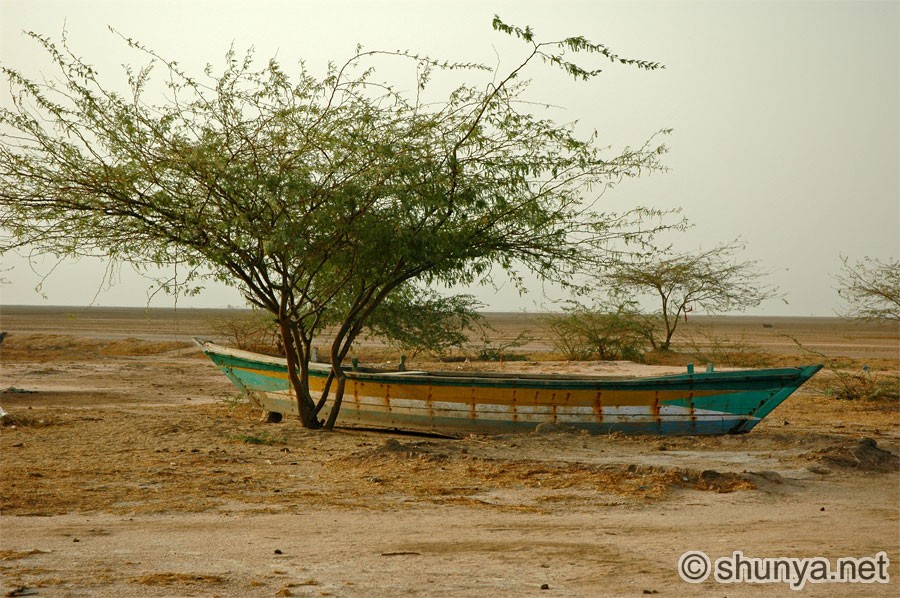
 This is the Rann of Kutch, an area about the size of Nagaland that is almost entirely within Gujarat, along the frontier with Pakistan. Once an extension of the Arabian Sea, the rann (‘salt marsh’) has long been closed off by centuries of siltation. During the monsoon, large parts of the Rann fill up with brackish water, enough for many locals to harvest shrimp. Some of these fishermen abandon their boats on the drying mudflats, presenting a surreal scene to dry-season visitors. Heat mirages abound, making distant objects hover strangely above the land. Further to the east, in the Little Rann of Kutch, is a wildlife sanctuary that protects the Asiatic wild ass, a shy and handsome animal that can sprint at speeds of up to 70 kilometres per hour. Now reduced to about 2800 in number, the wild ass depends on the few bets, or grassy islands, nourished by monsoon rains. The sanctuary also contains a large number of local and migratory birds, especially flamingos, in its many wetlands. This is the Rann of Kutch, an area about the size of Nagaland that is almost entirely within Gujarat, along the frontier with Pakistan. Once an extension of the Arabian Sea, the rann (‘salt marsh’) has long been closed off by centuries of siltation. During the monsoon, large parts of the Rann fill up with brackish water, enough for many locals to harvest shrimp. Some of these fishermen abandon their boats on the drying mudflats, presenting a surreal scene to dry-season visitors. Heat mirages abound, making distant objects hover strangely above the land. Further to the east, in the Little Rann of Kutch, is a wildlife sanctuary that protects the Asiatic wild ass, a shy and handsome animal that can sprint at speeds of up to 70 kilometres per hour. Now reduced to about 2800 in number, the wild ass depends on the few bets, or grassy islands, nourished by monsoon rains. The sanctuary also contains a large number of local and migratory birds, especially flamingos, in its many wetlands.
 The humans that live in this area lead an existence that is every bit as precarious. Dotting the parched landscape are desolate desert-like encampments, where a family or two combine forces to eke out a living by mining salt from the saline groundwater, the largest local industry. Local legend has it that when a salt worker dies and is cremated, the soles of his feet survive – a lifetime of saltpan labour bakes them so hard that even fire cannot fully consume them. The mined salt is eventually transported in Tata lorries to small trading posts along a nearby railway line. In the dry season, as far as the eye can see the land is dotted with hillocks of salt, where the precious mineral is packed and sent out on the trains for further processing. The humans that live in this area lead an existence that is every bit as precarious. Dotting the parched landscape are desolate desert-like encampments, where a family or two combine forces to eke out a living by mining salt from the saline groundwater, the largest local industry. Local legend has it that when a salt worker dies and is cremated, the soles of his feet survive – a lifetime of saltpan labour bakes them so hard that even fire cannot fully consume them. The mined salt is eventually transported in Tata lorries to small trading posts along a nearby railway line. In the dry season, as far as the eye can see the land is dotted with hillocks of salt, where the precious mineral is packed and sent out on the trains for further processing.
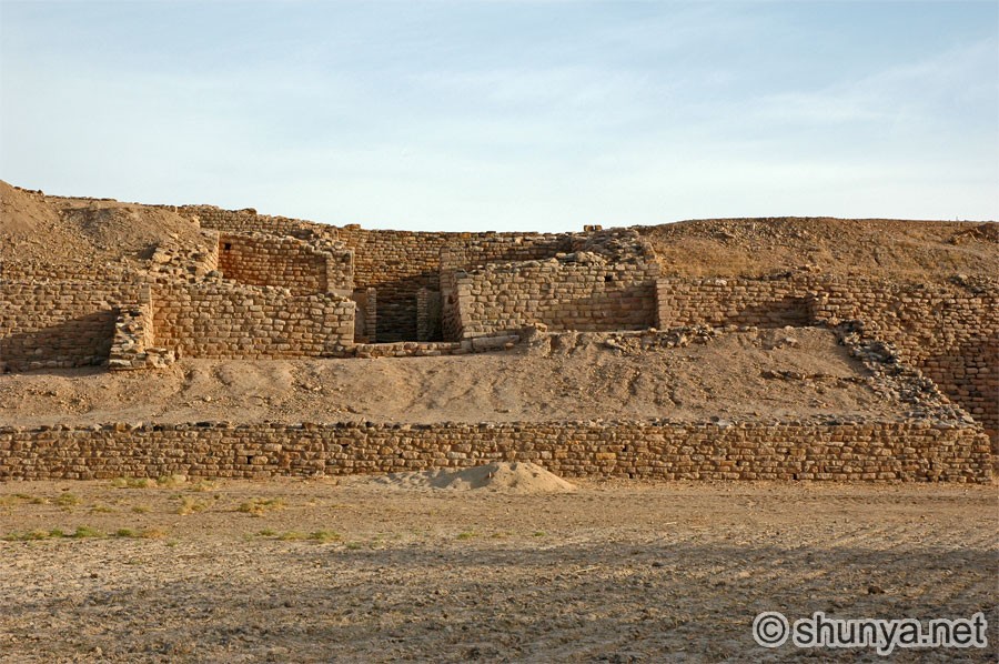
Larger human settlements in the Rann of Kutch are limited to a few island-like plateaus above the salt flats. One of these, Khadir, hosts the remains of the ancient city of Dholavira, discovered in 1967 and only excavated since 1989. While hundreds of sites from the Indus Valley Civilisation have been identified in Gujarat alone, the ruins of this 5000-year-old metropolis are among the six largest known in the Subcontinent, along with the Pakistani sites of Mohenjodaro in Sindh, Harappa and Ganeriwala in Punjab, and the Indian sites of Rakhigarhi in Haryana and the port town of Lothal, also in Gujarat.
 At the Dholavira site office, overseen by the Archaeological Survey of India (ASI), a caretaker and his friend are playing cards while lounging on a charpoy. They offer me a chair and a glass of water, cooled in an earthen surahi. A reminder of the historical mysteries of this region is prominently displayed on the outside wall of the office, with a reproduction of the inscrutable inscriptions from the famous mosaic signboard of Dholavira, which originally included ten characters, in a yet-untranslatable script, made out of gypsum. In the office, these are painted above contemporary motifs made from the decorative arts of Kutch, to suggest a continuity of sorts. The ASI still excavates here each winter, alongside researchers from overseas. During the digging season, hundreds from the village at Dholavira are employed at the site, and at the only tourist bungalow nearby. In the hot off-season, however, few outsiders show any interest. The caretaker tells me that I am the first visitor in three days. He offers to be my guide, adding that he has learned directly from the experts. I readily agree, and we set out to explore during what is surely the hottest hour of the day. At the Dholavira site office, overseen by the Archaeological Survey of India (ASI), a caretaker and his friend are playing cards while lounging on a charpoy. They offer me a chair and a glass of water, cooled in an earthen surahi. A reminder of the historical mysteries of this region is prominently displayed on the outside wall of the office, with a reproduction of the inscrutable inscriptions from the famous mosaic signboard of Dholavira, which originally included ten characters, in a yet-untranslatable script, made out of gypsum. In the office, these are painted above contemporary motifs made from the decorative arts of Kutch, to suggest a continuity of sorts. The ASI still excavates here each winter, alongside researchers from overseas. During the digging season, hundreds from the village at Dholavira are employed at the site, and at the only tourist bungalow nearby. In the hot off-season, however, few outsiders show any interest. The caretaker tells me that I am the first visitor in three days. He offers to be my guide, adding that he has learned directly from the experts. I readily agree, and we set out to explore during what is surely the hottest hour of the day.
Historic hydraulics
 To the casual visitor and researcher alike, the most striking feature of Dholavira is its water-management system. One gets the sense that, of necessity, every single drop of water in this parched land was saved. About 25 of the city’s 250 acres are taken up by 16 cut-rock reservoirs of various sizes, which harvested water from their catchment areas in the city as well as from two monsoon-season rivulets now called Mandsar and Manhar. Linked by intricate channels and dams, the reservoirs are quite spread out, and must have added a dramatic touch to the aesthetic appeal to this planned city. Looking at all this infrastructure, it is impossible not to wonder how much collective thought and energy went into saving water, and what drew Dholavira’s citizens to this location in the first place. To the casual visitor and researcher alike, the most striking feature of Dholavira is its water-management system. One gets the sense that, of necessity, every single drop of water in this parched land was saved. About 25 of the city’s 250 acres are taken up by 16 cut-rock reservoirs of various sizes, which harvested water from their catchment areas in the city as well as from two monsoon-season rivulets now called Mandsar and Manhar. Linked by intricate channels and dams, the reservoirs are quite spread out, and must have added a dramatic touch to the aesthetic appeal to this planned city. Looking at all this infrastructure, it is impossible not to wonder how much collective thought and energy went into saving water, and what drew Dholavira’s citizens to this location in the first place.
 Archaeologists have identified seven cultural stages in Dholavira’s evolution as a city, starting around 3000 BC. The ‘golden age’ was apparently the fourth stage, from the mid-to-late third millennium BC, when most of its monumental structures – gateways, fortifications, reservoirs – were built, accompanied by a prolific output in terms of pottery, inscribed seals, weights, beads and items of gold, silver, copper, ivory, shell, faience, soapstone, clay and stone. The fifth stage saw rising levels of impoverishment and urban decay, followed by a brief revival during stage six, until the area was finally abandoned around 1500 BC. As with much else about Dholavira in particular and the Indus Valley Civilisation in general, no one is sure exactly why this seemingly vital urban centre came to its final end when it did. We do know, however, that Dholavira outlasted other well-known sites such as Mohenjodaro and Harappa by as much as four centuries. Archaeologists have identified seven cultural stages in Dholavira’s evolution as a city, starting around 3000 BC. The ‘golden age’ was apparently the fourth stage, from the mid-to-late third millennium BC, when most of its monumental structures – gateways, fortifications, reservoirs – were built, accompanied by a prolific output in terms of pottery, inscribed seals, weights, beads and items of gold, silver, copper, ivory, shell, faience, soapstone, clay and stone. The fifth stage saw rising levels of impoverishment and urban decay, followed by a brief revival during stage six, until the area was finally abandoned around 1500 BC. As with much else about Dholavira in particular and the Indus Valley Civilisation in general, no one is sure exactly why this seemingly vital urban centre came to its final end when it did. We do know, however, that Dholavira outlasted other well-known sites such as Mohenjodaro and Harappa by as much as four centuries.
 Likewise, while we know that an outer wall enclosed the city, it is not clear from who it was meant to protect the citizens. Three major sections of the city have been identified: the ‘citadel’, ‘middle town’ and ‘lower town’, in descending order of prosperity and civic amenities. To the south, on higher ground, stands the citadel, where lived what is assumed to have been the royalty. Further north is middle town, with lower town to its east, both of which functioned as residential quarters for commoners, with streets and homes laid out on a grid-like plan. Outside many houses, the caretaker points out portable wastewater pots – similar to the large earthen matkas of today – that served as sullage jars. Pottery shards lay scattered about on the ground. I pick up a broken stone bangle, an accessory that could have been worn some four millennia ago. Likewise, while we know that an outer wall enclosed the city, it is not clear from who it was meant to protect the citizens. Three major sections of the city have been identified: the ‘citadel’, ‘middle town’ and ‘lower town’, in descending order of prosperity and civic amenities. To the south, on higher ground, stands the citadel, where lived what is assumed to have been the royalty. Further north is middle town, with lower town to its east, both of which functioned as residential quarters for commoners, with streets and homes laid out on a grid-like plan. Outside many houses, the caretaker points out portable wastewater pots – similar to the large earthen matkas of today – that served as sullage jars. Pottery shards lay scattered about on the ground. I pick up a broken stone bangle, an accessory that could have been worn some four millennia ago.
The imposing citadel, fortified with layers of walls, gates and towers, bears the remains of a castle at the very top, together with concealed passageways, stairs and chambers, many supported by chiselled pillars of finely polished limestone. What dramas unfolded within these walls? What fears and hopes were expressed here, and what myths, anxieties, humour, repressions, prejudices? Until the Harappan script is deciphered, much of how we answer these questions amounts to speculation (see Himal April 2007, “Cracking the Indus script”). Interestingly, it could even turn out that this much-discussed mystery is not a ‘real’ script at all. Recent American scholarship has made a compelling case that the Harappan inscriptions do not amount to a linguistic script, which could thus make their deciphering that much harder.
 What we can be sure of is Dholavira’s water-harvesting acumen, plainly evident in the citadel’s intricate network of storm-water drains, with slopes, steps, cascades, manholes, paved flooring and capstones. A tall person could walk through the large arterial drains that fed a reservoir on the citadel. The caretaker leads me to a deep well, once fitted with ropes and buckets, from which water cascaded down cut-rock channels to feed royal showers below. Who was allowed to occupy such a privileged spot, and which social organisation supported them? What we can be sure of is Dholavira’s water-harvesting acumen, plainly evident in the citadel’s intricate network of storm-water drains, with slopes, steps, cascades, manholes, paved flooring and capstones. A tall person could walk through the large arterial drains that fed a reservoir on the citadel. The caretaker leads me to a deep well, once fitted with ropes and buckets, from which water cascaded down cut-rock channels to feed royal showers below. Who was allowed to occupy such a privileged spot, and which social organisation supported them?
The grandiosity is not limited to the showers. Between the citadel and middle town is an open field, which was once enclosed on all four sides by stepped grandstands. This space could have hosted a market, royal or religious ceremonies, sports, executions, performances or festivals. Though there is no evidence of competitive sports having taken place here, some Indian historians prefer to believe so, and have accordingly dubbed the field a ‘stadium’. Overlooking this field was the citadel’s north gate, where the famous three-metre-wide signboard depicting the ten mysterious symbols was affixed. Interestingly, these huge characters would undoubtedly have been legible from clear across the field. For all we know, it could have said, Conserve water! – an injunction still worthwhile in today’s India, with its rising consumption, fast depleting groundwater, and increasingly fickle monsoon in the era of climate change.
 Notably, beyond the steady siltation, the local ecology, climate and precipitation are believed to have changed little since Dholavira’s heyday. The Rann, even today, has no natural sources of surface water, and the groundwater is generally too brackish to be potable. Local villagers now rely on a handful of deep wells, the construction of which has been enabled by modern technology, and on water piped in from the distant Narmada. Clearly, the local environment is a significant factor in making Dholavira unique from other Indus Valley Civilisation cities, even as it shared their penchant for town planning, centralised granaries, drainage systems and similar burial practices. In nearby Lothal, for instance, groundwater wells abound. Archaeological data from other Indus Valley sites suggests that, on average, every third house had a private well, in addition to many public wells. Notably, beyond the steady siltation, the local ecology, climate and precipitation are believed to have changed little since Dholavira’s heyday. The Rann, even today, has no natural sources of surface water, and the groundwater is generally too brackish to be potable. Local villagers now rely on a handful of deep wells, the construction of which has been enabled by modern technology, and on water piped in from the distant Narmada. Clearly, the local environment is a significant factor in making Dholavira unique from other Indus Valley Civilisation cities, even as it shared their penchant for town planning, centralised granaries, drainage systems and similar burial practices. In nearby Lothal, for instance, groundwater wells abound. Archaeological data from other Indus Valley sites suggests that, on average, every third house had a private well, in addition to many public wells.
 Indeed, with the area’s water resources clearly not ideal for agriculture, what economic activity could have driven the city’s fortunes and sustained people for centuries in this harsh environ? Scholars have suggested that Dholavira, with its coastal location, could have been a regional hub of maritime trade and commerce – after all, back then the Rann was a navigable channel all the way to the Arabian Sea. But, as ever, such ruminations are mostly speculative. Even so, based on what we know for sure, Dholavira strikes the modern visitor as a potent symbol of epic struggle against the elements, where a whole city strived to wrestle order out of a hostile environment – and did so successfully, for a millennia and a half. All for what? The stones have yet to start talking. Indeed, with the area’s water resources clearly not ideal for agriculture, what economic activity could have driven the city’s fortunes and sustained people for centuries in this harsh environ? Scholars have suggested that Dholavira, with its coastal location, could have been a regional hub of maritime trade and commerce – after all, back then the Rann was a navigable channel all the way to the Arabian Sea. But, as ever, such ruminations are mostly speculative. Even so, based on what we know for sure, Dholavira strikes the modern visitor as a potent symbol of epic struggle against the elements, where a whole city strived to wrestle order out of a hostile environment – and did so successfully, for a millennia and a half. All for what? The stones have yet to start talking.
More writing by Namit Arora?
|


